Mystery guests

When I was in the Berwyns last week, I saw a couple of plants that weren’t familiar. The first was just some broad crinkly leaves poking out of the usual ling and bilberry mix as I headed up the ridge path to Foel Wen. They were spread over quite a large area – several hundred metres at least.

I’m pretty sure they’re Cloudberry, and the Berwyns is one of the few places in Wales where you’ll find them. Unfortunately, they don’t give much fruit in the UK. Richard Mabey’s excellent book Food for Free has this wonderful bit of trivia:

In the Berwyn Mountains an unusual tradition commemorated this scarcity…  Shepherds from Llanrhaiadr believed that a quart of cloudberries was the wage that St. Dogfan was due for his spiritual ministry, and anyone who could bring such a quantity to the parson on St. Dogfan’s Day had his tithes remitted for the year.

The second unknown was a spread of these beautiful little yellow flowers in some sheep pastures on the lower slopes. Mountain Pansies

Berwyns without Tears

I’ve been meaning to spend some time in the Berwyns, as it’s one of the closest mountain areas to home. Unfortunately, it’s also on the way to Snowdonia, so the urge to drive straight past is hard to resist.

The Berwyn Hills have a reputation for trackless waist-high heather, and as I’m still recovering fitness this seemed a Bad Idea. But when you actually read the guidebooks, it seems there’s only a few outliers where this is an issue – the central peaks mostly have well established trails. After reading up in Peter Hermon’s Hillwalking in Wales, I decided on a circular route starting at Tan-y-Ffridd, taking in Cadair Bronwen, Cadair Berwyn and Moel Sych as well as a number of the smaller tops along the way.

The recommended start is at by the ‘phone box in Tan-y-Ffridd, but that junction now sports a large “No Parking” sign, so I drove about 500m further up the road to a section with a wide and mostly flat verge. After walking back along the road, you follow a track up through a farmyard towards Mynydd Tarw. The weather was just about hanging on. Hilltops on the other side of the valley were in and out of cloud, and I was guessing that I’d need my compass in earnest later. However, as I walked up the conditions slowly improved.

After a short snack in the windshelter, I headed on up the ridge towards Foel Wen and Tomle. There’s the usual peat moorland mix here of bilberry, ling and grass, but with some oddities thrown in. More anon.


After reaching the bwlch, the path right to Cadair Bronwen is straightforward, with a raised path built of railway sleepers preventing further erosion for much of the way. After a quick lunch, it was back down, and onwards to Cadair Berwyn. This is without a doubt the best part of the walk – and possibly one of the best walks in Wales outside Snowdonia. Keep as close to the cliff edge as possible, and the ground to your left just falls away to the valley floor, with incredible views.

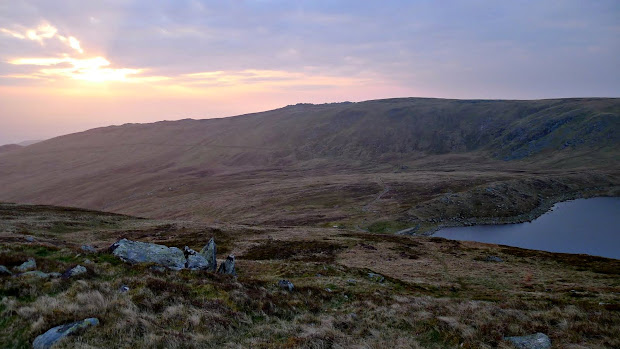
The trig point isn’t really worth a visit, as it’s not the true summit, which lies a few hundred meters further on at an impressive spiky jumble of rocks. On to Moel Sych, and then drop down on the path towards Llyn Llunclaws, which is a great spot to rest and take in the views back to the summit.


From here, I wanted to reach Moel yr Ewig, and that did involve some off-path wading through heather. Luckily only a few hundred meters, but I was glad to find an indistinct path snaking along the fenceline on the ridge. The path onwards to Godor is straightforward, although the fence lines don’t match the OS maps any more. Curiously the path was ‘waymarked’ by a significant amount of cottongrass, There’s a couple of peaty groughs to negotiate, and the second one made a good grab for one of my legs. Only up to mid-calf, luckily.

After reaching the top of Godor, you’re left with the tricky task of finding a route back to the start. You can do it by staying on access land and footpaths, but it’s a very long way round. I followed the fenceline straight down to a small spinney, then down through some sheep pasture and across the stream, hitting the road about 100m from the car. By the time I’d got boots off and in the car, the heavens opened. Perfect timing…

Download file for GPS

View in Google Earth

Cold Boot

Cefns ridge, winter

Yes, I finally got round to it…

I’ve been meaning to collate my trip reports and other outdoors-related bumf on a blog for a while. Content may start to appear in a topsy-turvy manner, with old reports deeply interwingled with new ones. I’m sure you can sort it all out.

Oh – and thanks for reading!

Cold and Wild

Carneddau, 18-April-2011

After a couple of trial pitches of the Scarp 1 in the garden, it was time to take it into the hills. I’d walked in the southern Carneddau above the Ogwen Valley a few times, but never ventured further north, so the parking by Trasbwll at the end of Llyn Eigiau seemed a natural place to start. Llyn Eigiau has a sad history – in 1925 the dam gave way  (poor foundations, allegedly) – taking a torrent of water and rocks down the valley to Dolgarrog, killing sixteen.

Driving through Dolgarrog, you can see the huge water pipes bringing water from the remaining reservoirs above to the hydro-electric plant. The drive up the narrow lane to Trasbwll gives great views into the cwm, but you’re forever opening and closing gates, or praying you don’t meet another vehicle on the hairpin bends.

I headed round the spur of Clogwynreryr and up to Melynllyn, the higher of the two reservoirs below Foel Grach. The idea of a going to the bothy at Dulyn crossed my mind, but I wasn’t going to get much experience with the tent by doing that. There was one pitch right by the reservoir that looked great, but instead I climbed higher to get some better views. I found a soft and  flat spot on the tongue between Melynllyn and Llyn Dulyn, and pitched the tent and settled down to eat. The Scarp was easy to pitch, even on the tussocky spot that I’d chosen. The Easton pegs provided are brilliant in this ground, and the tent felt rock solid, even without the crossing poles. The space inside is just amazing for a one person tent.


The weather had seemed pretty warm, so I’d packed the Marmot Atom sleeping bag rather than my heavier (and warmer) PHD one, but after getting sorted for the night, I realised this hadn’t been a great call. The temperature was only around +5, but I needed most of my spare clothes – including a synthetic gilet – to keep warm. I woke early, and after breakfast and a quick coffee was shivering as I packed up the tent. Once on the move I warmed up quickly, and the morning light was a great reward for the early start.

Sunrise over Craig Eigiau, Carneddau

Foel Grach in early morning light

I headed to the summit of Foel Grach, where there was a tent pitched next to the refuge – other than that hills were empty of walkers all day. From there, the route is easy to the rocky summit of Carnedd Uchaf (aka Carnedd Gwenllian now, thanks to the Princess Gwenllian Society) and on along the wall to Foel Fras. A group of Carneddau ponies were at the col between the summits, looking distinctly unkempt and the worse for wear after winter in the hills.

A quick diversion northwest from here reaches the top of Llwytmor, returning by contouring around the beautiful cwm above Llyn Anafon to reach Drum, and lunch in the windshelter.

Cwm Anafon, Carneddau

After Drum it was time to head home, but not before visiting the rocky top of Pen y Castell on the way. Heading back, I was buzzed several times by an AW-139 from the Defence Helicopter Flying School, doing circuits in Cwm Bychan.

The only spanner in the works was the flat tyre on the car when I reached it – a nail picked up on the road in, I guess. Luckily the spare was easy to fit, but driving home at 50 mph on a spacesaver wheel stretched my patience…

Download file for GPS
View in Google Earth

Hillwalking, and other frivolous pastimes