Category Archives: Wales

Unfinished Business

Nantlle Ridge – 17-August-2011

The only time that I’ve had to make a ‘strategic retreat’ was when heading up Y Garn on the Nantlle Ridge in 2009. I was at Rhyd Ddu to be a SARDA dogsbody for the weekend, and reckoned that a quick trip to the top and back was possible before the worst of the weather hit. After being blown off my feet for the second time a couple of hundred meters below the summit, I turned and headed downhill to drip copiously on the floor of the Cwellyn Arms in front of an open fire.

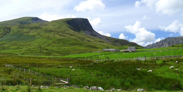
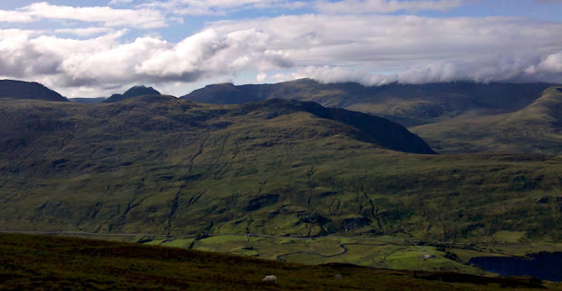
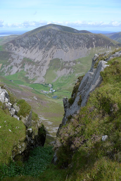
But Wednesday was different – the weather was set fine, and the cloud was high above the top of Snowdon, with hardly any wind. The climb up Y Garn is pretty unrelenting, but once you’re up the fun begins. There are dizzyingly huge gullies in the face towards Mynydd Mawr, and the ridge itself stretches away to the south like a rocky roller-coaster, with views of the sea on the one side, and Snowdon and Yr Aran on the other.

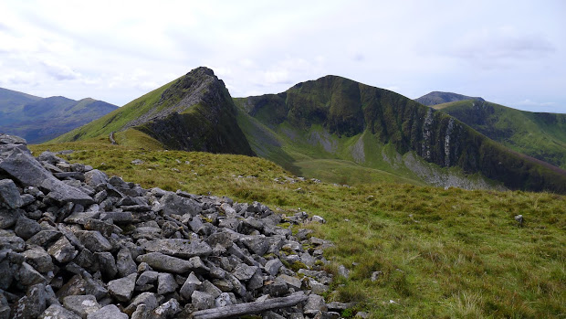
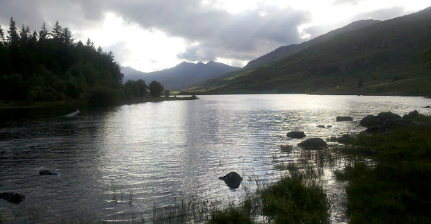
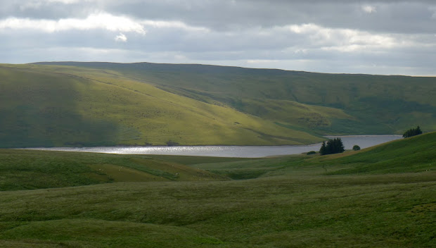
And it’s quiet – on a gorgeous day in the middle of the August holidays I saw just one couple walking the ridge ahead of me. I caught them up as they stopped for lunch by the Obelisk on top of Mynydd Tal-y-Mignedd, and after chatting for a while I headed back over the narrow neck before dropping down to the path through the Beddgelert Forest. Yes, there are dusty bulldozed forest tracks here, but the route stays mainly off them, winding past an old mine and out onto the lower slopes of Y Garn and back across the boggy stepping stones by Llyn-y-gader to the car park.

The mix of wide grassy tops and rocky scrambles here seems unique in Wales. I’m looking forward to walking the rest of the ridge soon.

Download file for GPS
View in Google Earth

The Best Camera?

Moel Siabod – 16-August-2011

I’d left my Lumix LX-5 safely tucked up in the dry for today’s ropework/nav refresher with Rob.

It was sufficiently nasty weather that we started indoors at the Llanberis MR team base, using traffic cones as anchors. The rain eased , so we headed outdoors and covered anchor selection, belaying, leader abseils, lowers and confidence roping on the side of the Llanberis pass. The weather was lifting as we moved on to Cwm Glas Bach for some navigation, combined with some impromptu search training for Skye, Rob’s border collie: Rob would pick a point on the map, I’d navigate myself there, then Skye would come and find me.

The cloud had lifted over the summits by then, so after finishing the day with Rob I decided to head up to the south ridge of Moel Siabod. I’d gone less than a mile before the heavens opened, and the tops disappeared once more into murk. Hoping this was temporary I pushed on up the damp rock of the scramble – meeting two guys retreating down it due to the poor visibility! After the obligatory couple of route adjustments and dead-ends (one near the top which seems to take you right out onto the eastern face), the sun magically broke through, casting shadows onto the mist below. I didn’t stay long at the top, as a beer at the Bryn Tyrch was calling me, and the I wasn’t sure if the cloud would stay away.  But, as I headed downhill towards Plas y Brenin the views of the Snowdon horseshoe, the Glyders, and the Carneddau behind were stunning. I could see the old NT farmhouse at Duffryn Mymbyr where we’d all spent a great weekend in June, and my destination – the Bryn Tyrch in Capel Curig – away in the distance.

The Mymbyr lakes are a perfect photo opportunity for Snowdon, so I pulled out my ‘phone to see if it could do any kind of justice to it.  I was pleasantly surprised with the results – The best camera really is the one you’ve got with you.

The Monk’s Trod

Elan Valley 5-August-2011

The Elan Valley is a fascinating place from a walker’s perspective – geographically dominated by the huge reservoirs of Claerwen, Craig Goch and Caban Coch and their dams, providing water for Birmingham and the Midlands. The bulk of the land compulsorily purchased is now managed by the Elan Valley Trust, formed in 1989 to encourage public access to the area – The hills here were free to roam long before the CROW act came into force. The trust also maintains a bothy at Claerddu with unheard of luxuries like a flushing toilet and gas lighting.

Only a couple of hills hit the magic 600m mark, but there is a huge expanse of rolling open moorland with hidden lakes and deserted farmhouses to explore. The valleys are really the heartland of Elenydd, beautifully captured in Anthony Griffith’s book and photographs.

Planning a circular walk isn’t easy here, as the rivers (and reservoirs) can make crossings difficult. Also – despite the open access – there are few paths shown on the map, and as I’d found from a previous visit, many of those don’t exist on the ground. Navigation in poor visibility can be challenging in the extreme.

I’d planned a circular route from the small car park at Pont yr Elan on the mountain road to Aberystwyth that would take me over the hills and down towards Claerwen, returning mostly cross-country to hit the road near the Craig Coch dam. A couple of miles of road walking would complete the loop, but that seemed a small price to pay.

The path I was following is the Monk’s Trod – an ancient road that joins the abbeys of Strata Florida and Abbeycwmhir. Legally it’s a BOAT – A Byway Open to All Traffic, but restriction orders have banned motorized vehicles from it for many years. Just as well, as the bog is so deep in places that you’d need a helicopter to pull out your 4×4. (It’s probably easier just to jump up and down on the roof until the entire vehicle is submerged…)

Despite the restrictions, there are still many places where you can see the damage to the peat from vehicles.

The highlight of the walk was reaching Cerriglywddion – here the continuous sea of moorland and peat is interrupted by two gorgeous lakes, surrounded by small rocky crests and summits. An old farmhouse – boarded and locked – is hidden here too, with every surface smothered in lurid green paint. If you stick to the path, you’d never see it, despite being just a few hundred meters away.

I headed back cross-country, eventually finding a faint quad-bike track from the plateau of Trumau down to the abandoned farm at Lluest aber-caethon. A couple of miles back up the road to the car before a gentle drive home to assemble a trampoline…

Download file for GPS

View in Google Earth

A Pair of Wellingtons

Black Mountain, Brecon Beacons, 14-July-2011

Not those, these:

Mynydd Du (the Black Mountain) is at the queiter western end of the Brecon Beacons National Park, and is very different in character to the central Beacons around Pen y Fan. There’s still the amazing red sandstone cliffs of the northern escarpment, but the land further south is much wilder, and rockier. The reason – Limestone. The geology of limestone areas is very distinctive, due to the way that the stone is eroded by rainwater, forming Karst landscapes, often with extensive cave systems.

My walk started from Dan yr Ogof, where there’s a large showcave and various other attractions including, rather surreally, a dinosaur park. However, parking is a reasonable £3 and you can get straight onto the hills without any road work. The weather was baking hot with a gentle breeze, and the sky a brilliant blue as I headed up past a group of Welsh ponies.

The limestone outcrops and sink holes make for interesting walking – a straight line is rarely an option, and there’s plenty to look at. It’s also a great place to practice navigation skills, but in poor visibility it would be exceptionally challenging.

I’d read the story about the MF-509 memorial and wreckage on Carreg Goch, and reckoned that would be a good objective to locate. The memorial cairn was surrounded by many wreaths and crosses, and seeing it and the wreckage in such a remote place was surprisingly moving. It amazes me how aluminium can resist the mountain weather so well for over 65 years.

I headed back to join the path which eventually fords the Afon Twrch, before fading out completely. After a stop for lunch it was a hot but straightforward slog up the hillside to Waun Lefrith where the drama of the escarpment is finally visible, with Lyn y Fan Fach far below.

It’s a brilliant and easy walk from here along the escarpment, with one steep pull as you reach the trig point of Fan Brychieniog, which gives great views over to Pen y Fan and the (other) Black Mountains.  I wanted to continue along as much of the Fan Hir ridge as possible, before dropping down to cross the Afon Haffes back towards the start, but this was mostly off path, and I needed to pick the best spot to cross before the river runs into the deepening gorge of Cwm Haffes. I aimed for some meanders just downstream from a waterfall and headed downhill.

About half-way down I saw a flash of red about 100m in front, and was very surprised when realised I’d stumbled on another memorial cairn with a poppy wreath. No dramatic wreckage here, just a handful of rusted metal and molten aluminium, which is all that’s left of Wellington BJ697.

I’ve finally cracked getting a GPX track from my Motorola Defy into the blog. Here’s the day’s route:

Download file for GPS
View in Google Earth