Category Archives: Walk Reports

A Pair of Wellingtons

Black Mountain, Brecon Beacons, 14-July-2011

Not those, these:

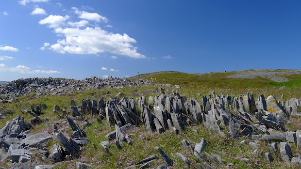
Mynydd Du (the Black Mountain) is at the queiter western end of the Brecon Beacons National Park, and is very different in character to the central Beacons around Pen y Fan. There’s still the amazing red sandstone cliffs of the northern escarpment, but the land further south is much wilder, and rockier. The reason – Limestone. The geology of limestone areas is very distinctive, due to the way that the stone is eroded by rainwater, forming Karst landscapes, often with extensive cave systems.

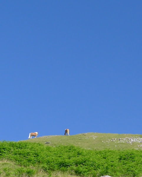
My walk started from Dan yr Ogof, where there’s a large showcave and various other attractions including, rather surreally, a dinosaur park. However, parking is a reasonable £3 and you can get straight onto the hills without any road work. The weather was baking hot with a gentle breeze, and the sky a brilliant blue as I headed up past a group of Welsh ponies.

The limestone outcrops and sink holes make for interesting walking – a straight line is rarely an option, and there’s plenty to look at. It’s also a great place to practice navigation skills, but in poor visibility it would be exceptionally challenging.

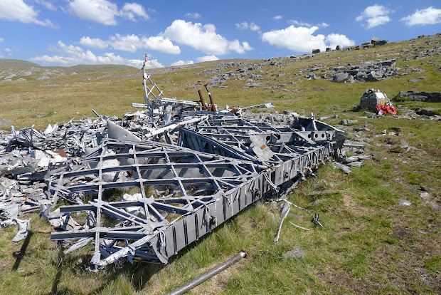
I’d read the story about the MF-509 memorial and wreckage on Carreg Goch, and reckoned that would be a good objective to locate. The memorial cairn was surrounded by many wreaths and crosses, and seeing it and the wreckage in such a remote place was surprisingly moving. It amazes me how aluminium can resist the mountain weather so well for over 65 years.

I headed back to join the path which eventually fords the Afon Twrch, before fading out completely. After a stop for lunch it was a hot but straightforward slog up the hillside to Waun Lefrith where the drama of the escarpment is finally visible, with Lyn y Fan Fach far below.

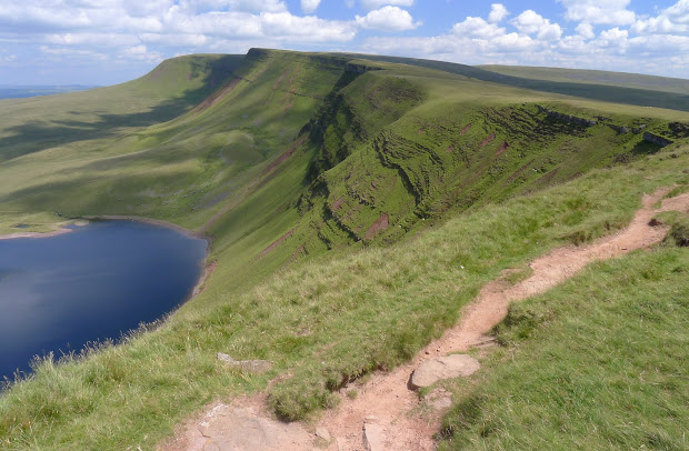
It’s a brilliant and easy walk from here along the escarpment, with one steep pull as you reach the trig point of Fan Brychieniog, which gives great views over to Pen y Fan and the (other) Black Mountains.  I wanted to continue along as much of the Fan Hir ridge as possible, before dropping down to cross the Afon Haffes back towards the start, but this was mostly off path, and I needed to pick the best spot to cross before the river runs into the deepening gorge of Cwm Haffes. I aimed for some meanders just downstream from a waterfall and headed downhill.

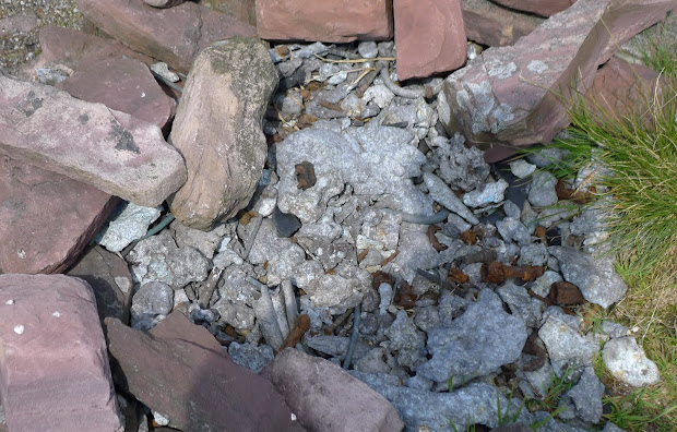
About half-way down I saw a flash of red about 100m in front, and was very surprised when realised I’d stumbled on another memorial cairn with a poppy wreath. No dramatic wreckage here, just a handful of rusted metal and molten aluminium, which is all that’s left of Wellington BJ697.

I’ve finally cracked getting a GPX track from my Motorola Defy into the blog. Here’s the day’s route:

Download file for GPS
View in Google Earth

Carneddau in the Clag

After an amazing overnight camp in the Carneddau in April, I had high hopes for Saturday’s last-minute decision to camp somewhere around Carnedd Llewellyn. The weather had been great, the suntan lotion was packed – but needless to say, things didn’t quite work out as intended.

I always love the cross-country blat up the back roads from Welshpool via Llangynog, with the Berwyns and  Hirnants either side of you, and Arenig Fawr on the skyline as you head downhill into Bala. The profiles of the Snowdonia mountains as the A5 climbs up from Cerrigydrudion was stunning, but tops all looked a little blurry…

I stopped for a pee at about 7:30  in Bettws. Not recommended, as the main public loos (20p a visit) were shut, with just a single loo (and queue to match) in operation. Worse yet, it was just a loo. No basin, towel, soap or hand-dryer.  0/10.

Onwards to Ogwen,  and I was parked in the long lay-by below Tryfan and walking by 8.05, giving me about 90 mins before sunset. Wanting to be camped up high not too long after then, I took the reservoir road to Ffynnon Llugwy, then climbed up to the ridge below Craig Yr Ysfa. I could see cloud just over the tops, but it was tantalizingly coming and going. Across the valley, Y Garn and Tryfan were both still clear. Before you reach the ridge, there’s one damp corner on the path which is worth exploring . You’ll see plenty of Butterwort (all in flower at the moment), but if you search carefully you can also find Sundew (also insectivorous) and  Milkwort here.

After you reach the ridge, there’s a brief but simple scramble up over Craig yr Ysfa. It feels pretty innocuous going up, but looking down the sense of exposure is phenomenal as you can’t easily see the ledge at the start of the scramble. As I reached the top, I had a bad twinge of cramp in one calf muscle, and decided that now would be a good time to find a pitch. At around 9:45 I found a flat spot with decent shelter and put the tent up and got supper on the go, watched by eight wild Carneddau horses, including a foal that can only have been a few weeks old.

After the daylight went, I took a map, compass and headtorch and headed on up for a wander.  The fog had come down noticeably, and while the torch was great for seeing the rocks I was walking on it was little use for identifying the path. I turned round after about 20 mins and navigated my way carefully back to the tent.

Plenty of rain in the night, and I could hear the wind getting up, but the Scarp was brilliant, even though I’m still working out how to get it rigged best. It was light around five, but I dozed on until seven when I saw how little I could see outside…

I got the camera out to capture the tent in all the clag, only to be greeted by a “Please Charge Battery” message, and little else. The weather had closed in, and visibility was down to about 20 yards. I ate and packed, then headed on up to the summit, waterproofs now on. The original plan was to go out and back to Yr Elen, on to Carnedd Dafydd, then back to the car via the SE ridge of Pen yr Ole Wen, but Yr Elen would wait for another day.

I met the first group of the day as I headed down towards the Black Ladders – a Paddy Buckley runner with a small group of supporters. He’d been running for around 21 hours and would have covered about 90km over 40 peaks in that time.

The wind picked up on the ridge to Carnedd Dafydd, and got even stronger below Pen yr Ole Wen at the head of Cwm Lloer, but as I dropped down the ridge towards the A5, the rain had stopped and I came out below the cloud. The weather had taken it out of me more than I’d realised, as I was slow, tired, and far from confident on the short gully scramble down to the Afon Lloer. From there, you head to the ladder stile, and then the way to the road is marked by the occasional white post.

Download file for GPS
View in Google Earth

Mystery guests

When I was in the Berwyns last week, I saw a couple of plants that weren’t familiar. The first was just some broad crinkly leaves poking out of the usual ling and bilberry mix as I headed up the ridge path to Foel Wen. They were spread over quite a large area – several hundred metres at least.

I’m pretty sure they’re Cloudberry, and the Berwyns is one of the few places in Wales where you’ll find them. Unfortunately, they don’t give much fruit in the UK. Richard Mabey’s excellent book Food for Free has this wonderful bit of trivia:

In the Berwyn Mountains an unusual tradition commemorated this scarcity…  Shepherds from Llanrhaiadr believed that a quart of cloudberries was the wage that St. Dogfan was due for his spiritual ministry, and anyone who could bring such a quantity to the parson on St. Dogfan’s Day had his tithes remitted for the year.

The second unknown was a spread of these beautiful little yellow flowers in some sheep pastures on the lower slopes. Mountain Pansies

Berwyns without Tears

I’ve been meaning to spend some time in the Berwyns, as it’s one of the closest mountain areas to home. Unfortunately, it’s also on the way to Snowdonia, so the urge to drive straight past is hard to resist.

The Berwyn Hills have a reputation for trackless waist-high heather, and as I’m still recovering fitness this seemed a Bad Idea. But when you actually read the guidebooks, it seems there’s only a few outliers where this is an issue – the central peaks mostly have well established trails. After reading up in Peter Hermon’s Hillwalking in Wales, I decided on a circular route starting at Tan-y-Ffridd, taking in Cadair Bronwen, Cadair Berwyn and Moel Sych as well as a number of the smaller tops along the way.

The recommended start is at by the ‘phone box in Tan-y-Ffridd, but that junction now sports a large “No Parking” sign, so I drove about 500m further up the road to a section with a wide and mostly flat verge. After walking back along the road, you follow a track up through a farmyard towards Mynydd Tarw. The weather was just about hanging on. Hilltops on the other side of the valley were in and out of cloud, and I was guessing that I’d need my compass in earnest later. However, as I walked up the conditions slowly improved.

After a short snack in the windshelter, I headed on up the ridge towards Foel Wen and Tomle. There’s the usual peat moorland mix here of bilberry, ling and grass, but with some oddities thrown in. More anon.


After reaching the bwlch, the path right to Cadair Bronwen is straightforward, with a raised path built of railway sleepers preventing further erosion for much of the way. After a quick lunch, it was back down, and onwards to Cadair Berwyn. This is without a doubt the best part of the walk – and possibly one of the best walks in Wales outside Snowdonia. Keep as close to the cliff edge as possible, and the ground to your left just falls away to the valley floor, with incredible views.

The trig point isn’t really worth a visit, as it’s not the true summit, which lies a few hundred meters further on at an impressive spiky jumble of rocks. On to Moel Sych, and then drop down on the path towards Llyn Llunclaws, which is a great spot to rest and take in the views back to the summit.


From here, I wanted to reach Moel yr Ewig, and that did involve some off-path wading through heather. Luckily only a few hundred meters, but I was glad to find an indistinct path snaking along the fenceline on the ridge. The path onwards to Godor is straightforward, although the fence lines don’t match the OS maps any more. Curiously the path was ‘waymarked’ by a significant amount of cottongrass, There’s a couple of peaty groughs to negotiate, and the second one made a good grab for one of my legs. Only up to mid-calf, luckily.

After reaching the top of Godor, you’re left with the tricky task of finding a route back to the start. You can do it by staying on access land and footpaths, but it’s a very long way round. I followed the fenceline straight down to a small spinney, then down through some sheep pasture and across the stream, hitting the road about 100m from the car. By the time I’d got boots off and in the car, the heavens opened. Perfect timing…

Download file for GPS

View in Google Earth